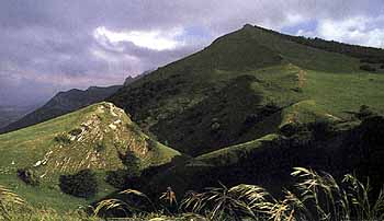
The Sibillini mountains offer some of the most breathtaking scenery in the whole of Central Italy. The area, however, still remains well off the usual tourist beat. The roads along this route remain almost deserted apart from winter skiers and intrepid ramblers in high summer. Yet, for the most part, though they twist about through some of the Marche's remotest areas, they are reasonably easy to drive.
Parco dei Sibillini
The mountains take their name from a legend that one of the sibyls - the prophetesses of classical mythology - hid here in a cave on Monte Sibilla known as the Grotta delle Fate (Cave of the Furies) when she was chased out of the underworld.
The literal highspot of this tour is a visit to the solemn upland plateau of Piano Grande, one of Italy's natural wonders, guarded by the solitary hill village of Castelluccio. The route also passes close under the peaks of Monte Vettore, the Marche's highest mountain.
But the tour is not just wild mountains. Along the way there are some beguiling small towns that each boast some real architectural gem. Best of all is friendly Visso waiting to be discovered by the adventurous tourist.
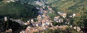
Visso
Sarnano is a handsome town with an even more handsome backdrop of snowy peaks. With a good range of hotels, it makes an ideal base camp for this tour.
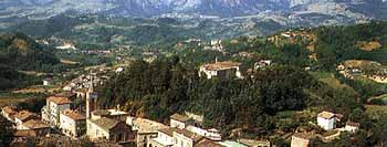
Some of the villages along the route have petrol stations but you are well advised to fill up before setting out. During winter months, though the roads are usually kept clear, make sure you have snow chains on board if you are driving the highest stretches. During the summer you are well advised to carry a bottle or two of mineral water and a good pair of hiking boots to strike off on foot into the inviting mountains. lies along the main SS.78, roughly half way between the two provincial capitals of Macerata and Ascoli Piceno. The waters of this small spa town are claimed to be beneficial for a whole gamut of complaints, including gout, arthritis and liver complaints. The quiet medieval borgo, topped by two solid towers, stands to one side of the modern town. A steep winding street leads up to a beguiling little square, Piazza Alta, flanked by the church of Santa Maria Assunta and the town’s medieval municipal buildings - Palazzo del Popolo with its finely decorated Gothic-Romanesque portal, the Torre Civica, the Palazzo dei Priori and the Palazzetto del Podestà. The more recent Palazzo Municipale, half way down in via Leopardi, houses a small art gallery which includes a Madonna and Child with two angels by Vittore Crivelli, younger brother of the more famous Carlo.
The Route
Part I - Sarnano to Bolognola
Sarnano lies along the main SS.78, roughly half way between the two provincial capitals of Macerata and Ascoli Piceno. The waters of this small spa town are claimed to be beneficial for a whole gamut of complaints, including gout, arthritis and liver complaints. The quiet medieval borgo, topped by two solid towers, stands to one side of the modern town. A steep winding street leads up to a beguiling little square, Piazza Alta, flanked by the church of Santa Maria Assunta and the town’s medieval municipal buildings - Palazzo del Popolo with its finely decorated Gothic-Romanesque portal, the Torre Civica, the Palazzo dei Priori and the Palazzetto del Podestà. The more recent Palazzo Municipale, half way down in via Leopardi, houses a small art gallery which includes a Madonna and Child with two angels by Vittore Crivelli, younger brother of the more famous Carlo.
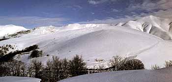
The tour heads off up into the mountains above Sarnano. From Piazza della Libertà, in the modern part of the town, follow the signs for Sasso Tetto. A good wide road winds up the mountain slopes, through beech wood coppices and limestone crags until, after about twelve kilometres, it reaches Sasso Tetto, one of the Marche's main ski resorts, and well equipped with ski lifts and accommodation.
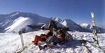
Piste di sci - Bolognola
Continuing on, the road rises to the Meta Pass before dropping to Bolognola. At 1070 metres, Bolognola has the distinction of being the highest village in the Marche as well as the smallest council district, with only 180 inhabitants to govern. This remote hideaway was founded in the 13th century by three families who fled from Bologna during the wars between the Papal Guelphs and the supporters of the Holy Roman Emperor, the Ghibellines.
Part II - Bolognola to Visso
Continuing onwards, the road drops gently down through Acquacanina (the beautiful Parish Church of Santa Maria di Rio Sacro on the right was founded by the Benedictines around the year one thousand and contains several notable paintings) and on to Fiastra. Here, the artificial lake, a haven for fishermen and windsurfers, stretches for over four kilometres along the valley of the River Fiastrone. Bear left and up towards the village, passing the ruins of a 11th century castle on a pine-clad hillock to the right of the road. It was the home of the ruling Malagotti family in the 1400s. A century later, Benedictine monks used the site to build the church of San Paolo whose slim tower rises up from within the ruins.
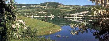
Lago di Fiastra
Leaving the mountains behind for a while, we drive through a more gentle landscape of pocket handkerchief fields squeezed between wooded hillocks until we arrive at Pievebovigliana. Stop here to admire the fine Romanesque parish church of Santa Maria Assunta It sits on a hillock, at the centre of the original settlement and above the more recent village. Inside the perfectly preserved 12th century Romanesque exterior, one eighteenth century priest decided to give the place an up-to-date neo-classical refit. Fortunately, he didn’t get as far as the beautiful crypt. Like many early churches, it was built using materials from ancient Roman times. The vaulted roof is supported by Roman pillars and a doorway has been blocked up with a stone tablet from the 2nd century.
Driving onwards towards the main SS.77, note the slim bridge which used to carry the road over the River Chienti - it stands to the right of the present road, just before the junction Here again, the foundations go back to the Roman period. Heading west along the main road, we leave it after just over a kilometre to turn south along the SS.209, passing Pieve Torina (whose own Romanesque church was badly knocked about by the 1997 earthquake) and enter the wood-flanked Valnerina valley.
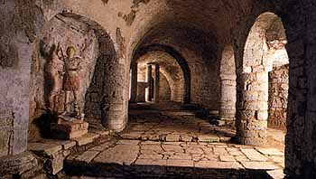
Cripta longobarda - Romitorio dei santi - Pievetorina
The tiny town of Visso, a few kilometres further on, holds one of the architectural delights of the southern Marche, yet it is so far off the tourist track as hardly ever to excite much interest. Driving through Porta Santa Maria, we enter Piazza Capuzi, an intimate triangular square of medieval stuccoed buildings, with both rounded and pointed gothic arches and stone corbels, presided over by the Palazzo dei Governatori. Across the way, to the left, in the adjoining Piazza Martiri Vissani is the splendid Romanesque-Gothic collegiate church of Santa Maria, its beautiful main portal flanked by two carved lions. Inside the church, you’ll find a gigantic 14th century fresco of Saint Christopher with an almost pagan stare to it, which looms up nearly to touch the coffered ceiling. Admire also the Romanesque baptistery in the rear corner of the nave with a pair of magnificent 14th century carved stone sarcophagi.
Back in the square, several shops sell cured meats for which this area is famous. These include the soft pork salami, ciauscolo, , and coglioni di asino (donkey meat and called coglioni , or testicles, only because of the shape). Ask one of the shopkeepers to make up some filled rolls, or panini, for a mountain picnic in one of the remoter areas further along the route.
A detour to Ussita, on the slopes of Monte Bove above Visso, takes you up to another popular mountain ski resort which in summer time is transformed into meadows carpeted with rare species of alpine flowers.
Part III - Visso to Piano Grande
From Visso, follow the signs to Castelsantangelo sul Nera. Here, the road begins to zigzag up until you arrive at the Nera pass. Suddenly ahead of you, at the far end of a natural basin, stands the lone village of Castelluccio. This cluster of houses, piled up on a rocky outcrop, is perhaps the remotest part of Central Italy and stood almost abandoned until a few years ago. At first sight it seems hard to understand why it was ever built. But once you climb the last stretch of road into the village, the reason becomes apparent. On the other side, stretching out for almost ten kilometres is the ethereal Piano Grande.
Monte Prata - Castel Sant'Angelo sul Nera
This vast fertile plain, over 1400 metres above sea level, is one of the most awesome natural sights in Italy and the home of another famous regional product, the lentil. The small, thin-skinned Castelluccio lentil is sown here and harvested in late summer. Stop to experience the overwhelming silence of the place, broken only by the sound of the Castelluccio church bell - in bad weather, the bell rings continuously until the village’s tiny population are all home.
Part IV - Piano Grande to Montefortino
Half way across Piano Grande, the road divides. Our route takes us to the left (following signs in the direction of Ascoli Piceno). Reaching the pass at Forca di Presta the rugged southern crags of Monte Vettore come into view on the left. At 2476 metres, this is the highest mountain in Central Italy and will remain our constant companion for the remainder of the journey. Out ahead of us to the south stretch the Monti della Laga, the next link in the Apennine chain, in the Abruzzo region. As the road threads downwards, now follow the signs for Montegallo. Before long, signs of human habitation return. The principal livelihood of the tiny mountain communities in this area comes from coppicing the woodland slopes.
Arriving at Balzo di Montegallo, the mighty eastern face of Monte Vettore looms into sight. Stop at the village belvedere to take a closer look through the coin-operated telescope or pause in the welcome shade of a nearby bar. Continuing on down into the valley, follow the signs to Comunanza and then Montemonaco The road snakes down and onwards under the ever present gaze of Monte Vettore. Just before the village of Montemonaco, a 15 kilometre dead-end detour takes you to the Gola dell’Infernaccio, an awe-inspiring gorge carved through the rock by the river Tenna.
Passing through the village of Montemonaco, the road edges along a knife-edge spur before winding on to the mountain stronghold of Montefortino. Park just below the village to wander around its picturesque narrow streets (you can drive into the village but only if you are confident that you know your car width well). The Palazzo Municipale houses the charming small Fortunato Duranti collection of 15th and 16th century paintings donated by a local artist during the last century (open weekday mornings from 1000-1300hrs). Just after the village, a twelve kilometre detour to the left leads along the beautiful valley of the River Ambro to the 17th century Sanctuary of the Madonna dell’Ambro. This has been a place of pilgrimage since 1073, when a mute shepherdess saw an apparition of the Madonna. Alternatively, you can take another detour up to the Gola dell’Infernaccio
The route now heads for Amandola. Follow its main street up to the smart porticoed Piazza del Risorgimento. As you sip your aperitivo at one of the bars, admire the clock over the Baroque Porta San Giacomo and the sunken frontage of the church of Sant’Agostino with its 15th century Gothic-Venetian portal. Further up, in Piazza Umberto I, one tower is all that remains of the 14th century stronghold which protected the town.
Amandola
If you are here in the first week of September, you can watch some of the many events staged during the annual International Theatre Festival, whose reputation has spread well beyond the regional boundary. The town hall also houses a rural history museum - Il Museo della Civiltà Contadina - open Tuesday to Friday 0800-1300hrs. Home base at Sarnano is now just 12 kilometres away along the main SS.78.
Routes
Tour 1 - The Castles of Montefeltro
Tour 2 - From Paper to Stone
Tour 3 - The Vineyards of Verdicchio
Tour 4 - The Heartland of Le Marche
Tour 5 - In the Shadow of Monte Conero
Tour 6 - The Wild Mountains of the Sybil
Tour 7 - In the Footsteps of Ancient Rome
Tour 8 - Ascoli's Hidden Heritage
Tour 9 - Beside the Seaside
© Liberation Ventures Ltd.